


Article published in the Canadian Journal of Remote Sensing. Citation and abstract only.
Abstract
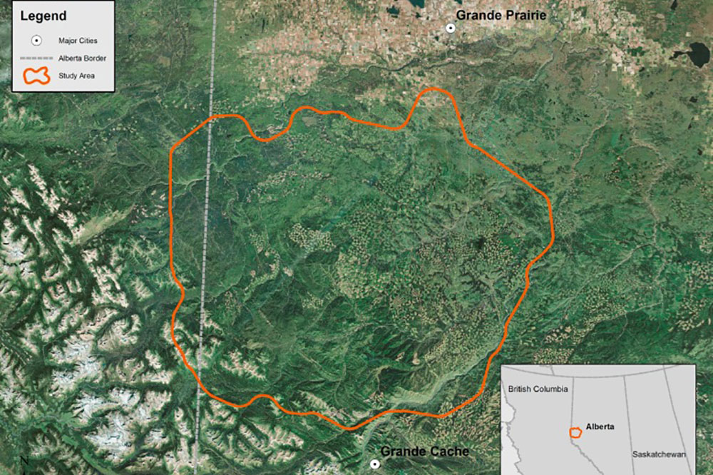
Landscape change, specifically habitat loss and modification, is thought to have an impact on the health, productivity, distribution, and survival of grizzly bears (Ursus arctos L.). Although grizzly bears may preferentially seek out areas of anthropogenic disturbances for foraging opportunities, research has found that grizzly bears experience greater mortality in these areas as a result of increased human access. Additional insights on the location and rates of anthropogenic-driven landscape change are required to better understand related impacts upon grizzly bears. In this study, a time series of 14 Landsat MSS, TM, and ETM+ images were used to retrospectively document and quantify the rate of landscape change over a 35-year period from 1973 to 2008 in a 13 507 km2 analysis area in western Alberta, Canada. The study area is located within a larger region that contains the highest density of grizzly bears in Alberta and has experienced increasingly intensive forest harvesting and oil and gas exploration activities during this period. To accommodate the differing spectral channels from MSS to TM/ETM+ sensors, the arctangent of the angle of the Tasseled Cap greenness-to-brightness components was computed for each image year, with sequential image pairs differenced and a threshold applied to identify stand-replacing disturbance events. Results indicated that 11% of the analysis area experienced some form of stand-replacing disturbance (e.g., cutblocks, roads, oil and gas well sites, seismic lines, power lines, pipelines, blowdown) between 1973 and 2008.The greatest proportion of this change (by area) occurred between 2004 and 2006 (24%), while the lowest proportion occurred between 2000 and 2001 (2%). Although the number of change events has fluctuated over time, with a minimum of 2888 change events between 1976 and 1978 (2%) and a maximum of 36 623 change events between 2004 and 2006 (29%), the mean size of change events has decreased over time: prior to 1995, mean event size was greater than 1.5 ha; after 1995, it was less than 1.5 ha. The annual rate of change was greatest between 2004 and 2006 (-1.25%), and lowest between 1981 and 1990 (-0.04%). Consideration of changes within the context of units relevant to grizzly bear management (i.e., grizzly bear watershed units and core or secondary habitat areas) indicate that the amount and rate of change was not spatially or temporally uniform across the study area. While the average change event size has decreased over time, the increasing number of change events has resulted in a larger aggregate area of change in more recent years. Landsat imagery provided a large-area, synoptic, and consistent characterization of 35 years of stand-replacing disturbance in our study area, providing information that enables an improved understanding of the complex interactions between grizzly bear distribution, abundance, health, survival, and habitat.
Citation
White, J. C., Wulder, M. A., Gomez, C., & Stenhouse, G. (2011). A history of habitat dynamics: Characterizing 35 years of stand replacing disturbance. Canadian Journal of Remote Sensing, 37(2), 234–251. doi:10.5589/m11-034