By Dan Wismer
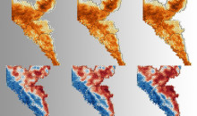
Alberta’s landscape is far from static, as each year natural and human disturbance changes characteristics in land and canopy cover. New wildfire events, road construction, forest harvesting and oil and gas activities open areas and reset the vegetation age, while older disturbed areas regenerate back to natural conditions. These constant changes play a major role in habitat quality, mortality risk and the overall habitat states of grizzly bears.

% canopy cover captures how open or closed the forest is.
Researchers and land managers want to understand where on the landscape change is occurring and the impact of that change. Using observed annual landscape layers and running them through GBTools, we can map probability of bear occurrence (RSF maps), mortality risk and the overall habitat state of the landscape between the years 2000 to 2018. Analyzing time series results will help explain other questions about population inventory results, carrying capacity and the overall health of our Alberta grizzly bears and their habitats.
fRI Research will continue to maintain and update GBTools into the future to help support conservation efforts and land management decisions.
Gallery