Quantifying Spatio-temporal Variability in Post-Mountain Pine Beetle Outbreak Fuels, in Jasper National Park Using Terrestrial Laser Scanning, and Bi-temporal Multi-spectral Airborne LIDAR
We understand little about the interaction between wildfire and MPB outbreaks. This is particularly relevant in Jasper National Park, where fires have been suppressed for over a century, potentially creating a highly susceptible landscape to wildfire. This project will assess stand structure and the fuels resulting from the MPB outbreak using LIDAR, terrestrial laser scanning and field-based fuel characterizations. This approach is novel and brings together several methods to assess wildfire fuels that can be utilized by land managers across Canada.
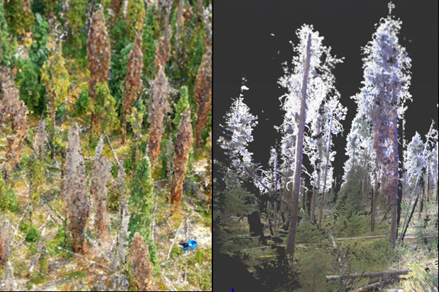
Identifying the green attack phase using optical remote sensing has remained elusive, however, we hypothesize that early onset of attack resulting in drying and some needle loss may alter structural properties and foliar moisture content which may be observed in bi-temporal and terrestrial lidar data and oblique thermal imaging. These changes may be enhanced by the reflective properties of needles and branches in different laser emission wavelengths.
We hypothesize that the spatial distribution, age of trees, and micro-climate will contribute to variations in fuels and their connectivity. We hypothesize that the period of red to gray attack phase and loss of biomass from the canopy to the ground-level detritus will contribute to fuel connectivity.
We hypothesize that there will be peaks for fire risk through time in the post-MPB disturbed environment. The first will be of moderate risk prior to and during the period of needle drop, when trees and branches remain standing and new broadleaf vegetation regenerates (Jolly et al. 2012). The second peak of risk associated with fire fuels will occur after 10 years post-MPB as standing stems and branches fall, contributing a pulse of coarse woody debris. A third peak will occur when coarse woody debris, including branches are further broken down and contribute to fine fuels, along with continued growth of regenerating broad leaf and conifer vegetation. We hypothesize that the second peak of fire fuels could result in greater intensity of fires and greater risk, especially in areas of warmer, drier micro-climate (e.g. south-facing slopes, higher elevation, deeper feather moss layer).
Objectives
- To quantify coarse and fine fuels at each attack phase by examining:
- change in pertinent structural fuel attributes using bi-temporal lidar data at the green, red and gray attack phases; and
- variations in structure and laser reflectance at different wavelengths.
- To determine:
- How outbreak duration and severity contribute to horizontal and vertical structures and fuel connectivity across attack phases.
- How do these outbreak characteristics interact with environmental landscape heterogeneity to influence or modulate risk.
- Using the methods developed in Objectives 1 and 2, to create a predictive model to map fuel structural attributes and composition in post- MPB-disturbed, from a chronosequence of stands as a function of environmental factors, outbreak severity, and time since the start of the outbreak.