Skip to content
close
fRI Research
  • Programs
  • Publications & Media
  • Subjects
  • News
  • About
    About
    • Who We Are
    • Annual Reports
    • Meet Our Team
  • Contact
  • Programs
  • Publications & Media
  • Subjects
  • News
  • About
    About
    • Who We Are
    • Annual Reports
    • Meet Our Team
  • Contact
Programs

Active Programs

Caribou Program
Caribou Program
Environmental Research Program
3 grizzly bears in a meadow in Kakwa
Grizzly Bear Team
aerial photo of a forested landscape with cutblocks
Healthy Landscapes Program
MPB-attacked forest with mountain backdrop
Mountain Pine Beetle Ecology Program
aerial photo of a road beside a large river in the foothills
Water and Fish Program
  • All Programs
  • All Projects

Associations

  • Alberta Regional Caribou Knowledge Partnership (ARCKP)
  • Caribou Patrol
  • Foothills Landscape Management Forum
  • Foothills Stream Crossing Partnership (FSCP)
  • Forest Growth Organization of Western Canada (FGrOW)
  • SERG International
Publications

Scientific Publications

  • Reports
  • Peer Reviewed Papers
  • Books
  • Theses
  • Interviews
  • Manual and Guides

Summaries and Communications

  • QuickNotes
  • Infographics
  • Resource Lists and Compendiums
  • Meeting Agenda and Proceedings
  • Posters
  • Presentation Slides
  • Fact Sheets
  • Annual Reports
  • Newsletters
  • Partner Perspectives
  • Media Articles

GIS Products

  • Interactive StoryMaps
  • Maps
  • Tools and Apps

Audio-Visual

  • Videos
  • Photo Galleries
  • Podcasts and Radio

Business Documents

  • Work Plans
  • Value Reports
  • Plans and Terms of Reference
  • Project Proposals
Subject

Animals

  • Birds
  • Caribou
  • Elk
  • Grizzly Bear
  • Moose
  • Mountain Pine Beetle
  • Mule Deer
  • Other Animals
  • White-tailed Deer
  • Wolf

Natural Disturbance

  • Climate Change
  • Fire
  • Landscape Change
  • Soil

Water & Fish

  • Aquatic Ecosystems
  • Fish
  • Hydrology
  • Riparian Ecosystems
  • Watershed

Resource Management

  • Access Management
  • Cumulative Effects
  • EBM
  • Environmental Monitoring
  • Forest Management
  • Integrated Land Management
  • Reclamation & Remediation

Plants

  • Aspen
  • Jack Pine
  • Lodgepole Pine
  • White Spruce
  • Whitebark Pine

Socio-economics

  • Community Development
  • Economy
  • Tourism & Recreation
  • Historical Land-use
News
Blog
Event
Announcement
//just links left to right

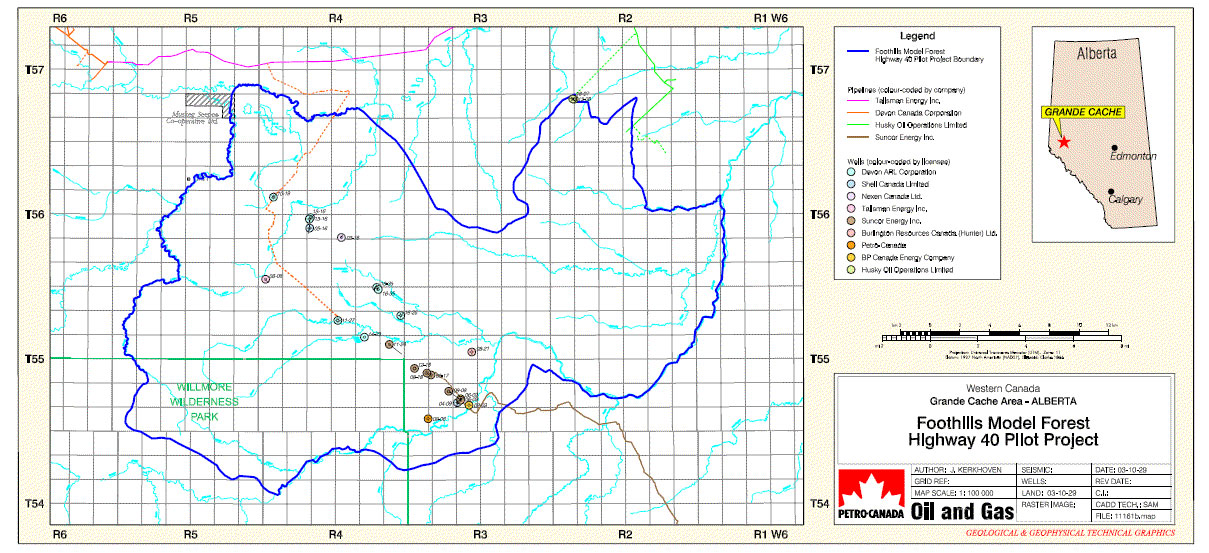
Foothills Model Forest Highway 40 Pilot Project Map – Pipelines and Wells

Map of Highway 40 Pilot Project area showing the pilot project boundary, pipelines and wells.

Map of Highway 40 Pilot Project area showing the pilot project boundary, pipelines and wells.

Downloads

HLP_2003_10_Map_FMFHwy40PilotProjectMap11161b.pdf
Author
Kerkhoven, J.
Published
Oct 01, 2003
Subject Area
EBM
Resource Management
Untagged
Record Type
Maps
GIS Products

Related Programs

  • Healthy Landscapes Program

Related Projects

  • The Highway 40 North Demonstration Project
  • About
  • Contact
  • Opportunities
  • Annual Reports
  • Media Kit

The fRI Research office is on Treaty 6 territory, specifically, the traditional lands of the Anishnaabeg, Aseniwuche Winewak, Cree, Métis, Stoney, and Tsuu T’ina Nations. We also wish to gratefully acknowledge that in carrying out our research, we live, learn and work in the ancestral territories of many First Nations, Inuit, and Métis peoples.

Sign Up for Our Newsletter

  • © Copyright © 2025 fRI Research
  • Privacy Policy