A new animation shows the movement of grizzly bears around a landscape of forests and cut blocks. The animation, made by Julie Duval of the GIS Program, uses real data from bears collared by the Grizzly Bear Program. It was created for the Alberta Forest Products Association (AFPA).
The fRI Research GIS Program is often the unsung hero supporting our other projects and programs. In the background, they quietly help manage our data, write computer programs that make the science we do more efficient, and contribute maps to reports and papers. Recently, however, there was an opportunity to do an animated visualization for the AFPA.
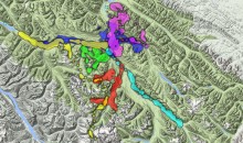
The animation shows the hourly locations of eight adult grizzly bears from May to July 2012. The data is displayed as a heat map, where each bear has its colour. As the animation runs, the coloured blobs spread and grow based on where the bears were on each successive hour.
The bears wander around an area of west-central Alberta that has seen forestry operations going back to 1975. The animation shows how bears spend time in the patches of unharvested forest, old cut blocks, and recent cut blocks.
The animation made its debut at the AFPA’s annual general meeting in September. The AFPA is a non-profit established in 1942 with the goal of fostering a greater understanding of the economic, environmental, and social values of Alberta’s forests.
The animation can be found via the AFPA’s website.
Gallery