By Caitlin Tomaszewski
In 2013 a massive flood hit the City of Calgary and surrounding areas. While the physical impact on towns and cities in Southern Alberta was easy to quantify, little research was done to assess the state of rural riparian areas in the Bow and Oldman watersheds in the Eastern Slopes. In 2015, the Water Program of fRI Research undertook a project in partnership with the Government of Alberta to assess the health of riparian areas in the Eastern Slopes through the Watershed Restoration and Resiliency Program (WRRP). The research set out to answer many questions about the natural riparian areas we can find in Alberta: what is the current health of watersheds and their respective riparian areas, can a protocol that was developed to assess streams in interior BC be applied to environments in Alberta, and finally, to what extent did the 2013 flood impact and damage riparian areas in the two watersheds of interest.
Using the FREP protocol, assessments were carried out on pre-determined streams in the Bow and Oldman watersheds. The protocol examines many aspects of riparian health which truly makes it all encompassing. First it looks at channel morphology regarding lateral and mid channel bars, as well as braided channels. It also examines how much of the channel banks are disturbed, either by flood or animals, and if this disturbance contributes sediment into the water. There are many measurements taken to determine if the aquatic environment is suitable for fish and invertebrates to thrive in, even going so far as to classify which invertebrates found are indicators of good environmental health. Finally, there is a section to help assess the state of the riparian area surrounding the stream. It includes measures of the diversity of cover (large trees, shrubs, forbs, moss, etc.) as well as assessing the form, vigor, and recruitment of each of these components. In this section, technicians are also asked to assess whether the surrounding forested area has been disturbed (by floods, animals, logging, recreation, etc.) and if the forest is host to any disturbance-increasing vegetation species or noxious weeds.

A map of all the assessments showing the current state of riparian areas in the Eastern Slopes. Lower PFC score = better health and condition.
Compiling all the above measurements and information into 15 “yes” or “no” questions gave us an overall PFC score for that stream, ranging gradually from healthy and properly functioning to unhealthy and not properly function. Photos taken from the start and end points of the assessment are shown for three categories of the PFC on the protocol, with some additional information on why these streams were classified into their respective categories, with causal factors being associated with these scores afterwards.
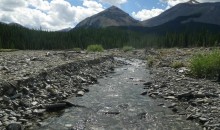
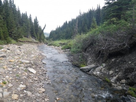
Unamed tributary in the Castle Mountain Region south of Castle Falls Campground. This site was properly functioning, with only one question receiving a “no” answer pertaining to high natural background sediment levels in the environment. This stream had a great riparian area and supported many groups of aquatic invertebrates as well as having many areas of suitable fish habitat.
The FREP protocol was originally developed to be used in interior BC with the aim of assessing impacts of logging and harvesting on riparian areas. With this in mind, the Albertan riparian crew was interested in seeing if this protocol could be applied to AB streams mainly outside of a logging context, and if there were any distinctive differences between the ecosystems of the two provinces. With Emma Hawksworth being from Kamloops BC and Caitlin Tomaszewski being a native of Calgary, the two had perspectives which would blend well throughout the season and help to raise some interesting questions about the project and protocol.
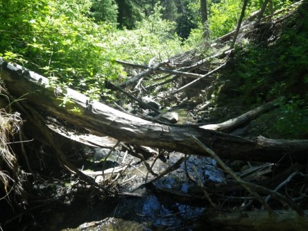
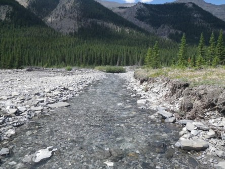
Rae Creek, a tributary in the Sheep River Region, East of highway 40 in Kananaskis. This site was assessed as properly functioning at risk with the causal factors being flood damage as well as the natural landscape of the environment and riparian area. This stream showed minor flood damage with some banks being scoured out which can contribute to high sediment loads.
Along with completing the protocols for each stream sampling point, the crew was asked to think about how the protocol could be improved and made more accurate when assessing streams in Alberta specifically. Along with wonderful fieldwork, in some of the most remote areas of the Eastern Slopes, the project also engaged the crew to think critically about the data that was being collected. After committing the protocol to memory and assessing dozens of streams over the 2017 season, the techs felt it was important to include ecoregion into the analysis and data collection. In interior BC, there are few streams surrounded by “prairie” environments like we have in Alberta. It was the techs opinion that a stream shouldn’t be classified as “unhealthy” just because it wasn’t surrounded by trees like in BC. Alberta has many different ecoregions, even within the Eastern Slopes, that can cause unique cases when assessing riparian areas. There was also talk about doing a more extensive riparian evaluation and completing detailed vegetation assessments (naming genus and species) to help interpret the specific make up of the surrounding area to the stream.
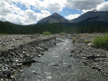
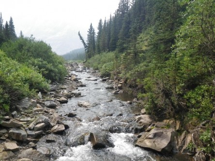
Cougar Creek, a tributary to Elbow River, along the Big Elbow Trail in Kananaskis. This site was assessed as not properly function with the primary causal factors being flood damage. You can see the blow-out on the flood plain. This site had many disturbed banks with little surrounding vegetation and almost no aquatic life.
After the field season, Caitlin set to work analyzing the data. She began with only descriptive statistics, utilizing pivot tables in excel, to gain some insight into the data set she was working with. It was clear from the get go that there was a large amount of variability in the data. This confirms the suspicions that the Eastern Slopes of Alberta are filled with a variety of ecoregions and constitute a complex environment. Preliminary analysis shows that throughout the three seasons this project was conducted, it was determined that 55% of the streams assessed from 2015–2017 were impacted by damage caused by the natural event of the 2013 flood. Along with the natural flood event, many streams with declined health were attributed to agriculture (specifically livestock) as well as logging and recreational roads.

Results for the project have only been descriptive up until this point. Caitlin is hoping to dive into more analytical statistics this fall with the eventual goal of developing a scientific paper to answer the main objectives stated above. Future directions for this project hope to see a predictive model created as a management tool for stakeholders looking to determine, mitigate and improve riparian function and health in the Eastern Slopes of Alberta.
Finally, this project would not have been possible without joint help from the Government of Alberta, specifically the Alberta Environment and Parks and Alberta Agriculture and Forestry departments.
More information about this project and the WRRP more generally.
Gallery